
Exclusive Economic Zone & UNCLOS
States Exclusive Economic Zones (EEZ) extend no more than 200 nautical miles from the territorial sea baseline and is adjacent to the 12 nautical mile territorial sea. The Part V Article 55 of the United Nations Convention on the Law of the Sea (UNCLOS) defines the EEZ as:
“The exclusive economic zone is an area beyond and adjacent to the territorial sea, subject to the specific legal regime established in this Part, under which the rights and jurisdiction of the coastal state and the rights and freedoms of other States are governed by the relevant provisions of this Convention.”
To elaborate matters further in the year 1982 the United Nations Convention on the Law of the Sea defined a set of rules on how to divide the marine regions. A country has control over both the seafloor as well as ships travelling at the sea surface in an area that extends up to 12 nautical miles (22.2 km) from its coastline.This is called a country’s territorial sea and its outline is similar to the borders that exist on land.
Extending beyond this point and reaching up to 200 nautical miles (370.4 km) from a country’s coast lies its Exclusive Economic Zone. Within this region a country owns the natural resources at the seafloor but has no say on what happens at the surface. Any ships in an Exclusive Economic Zone are essentially in international waters.
The jurisdiction of the coastal state within the EEZ only pertains to natural resources (fish, offshore oil and gas). Issues emerge in cases where jurisdiction over sedentary and underground resources is wider when the continental shelf extends beyond 200 nm and the legal parameters for such an eventuality are provided for in Article 76 of UNCLOS . At an earlier stage the 200 meter depth contour was generally acceptable as the limit of the continental shelf. The sedentary living resources are defined in UNCLOS as fixed to the bottom or unable to move unless in contact with the ocean bottom. In situations where maritime countries share the same continental shelf or the distance between their shores is less than 400 nautical miles boundaries between maritime states are settled by negotiations usually resorting to the equidistance principle. Complications arise when sovereignty claims are made over over uninhabited islands.
What Constitutes a Sea Port
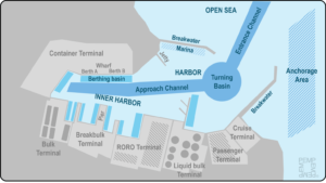
Harbor is a protected marine area, either naturally or through the construction of structures such as breakwaters where port activities occur. The depth and navigation of a port are strictly controlled. The inner harbor usually refers to the port area the furthest away from the entrance channel, which has the oldest and most central port facilities. Ports depict variety of harbours.
Anchorage areas are designated areas where ships can anchor while waiting for an available berth. These areas are well-defined with buoys and with the ability to be serviced for stores and bunkering. At times anchorage areas are located within the harbor.
Breakwaters are permanent structures extending into the sea to protect the harbor against tides, currents, waves, wind and storm surges. Navigation channels are ship access channels dredged to allow ships to enter the harbor. They have a controlled depth and movements are usually assisted by pilots and tug boats. Approach channels serve a similar role but refer to navigation taking place within the harbor.
Turning basin is a circular area allowing for vessels, assisted by tug boats, to turn around and maneuver into the harbor. By design a turn basin should be twice the length of the largest permitted vessel to call at the port.
 Credit; Portseconomicsmanagement.com
Berthing basin is a dredged area next to a berth that allows a ship to be moored according to stated specifications and to ensure that ships of specific capacity and length can safely berth. Each berthing basin has a well-defined control depth requiring periodic maintenance.
Berths (or docks) are docking structures with defined length and lateral capacity to support berthing and mooring operations. Wharves are one or more berths aligned parallel to the shore. Piers are docking structures extending into the sea and are extensions of the terminal facility. A pier can hold facilities such as storage sheds and warehouses. Jetties are narrow docking structures extending into the sea that serve the sole purpose of loading (unloading) cargo into ships not being direct extensions of terminal facilities.
These physical elements are designed to support the core function of a port, which can be composed of a variety of terminals such as bulk, breakbulk, cruise and container terminals, each connected to its own hinterland. Physical elements may not always be present depending on the physical characteristics of the port site as some ports may not require breakwaters as they may already be in protected areas or have low tides and currents.
Analysis by Nadir Mumtaz & Hafiz Munawwar Iqbal ASC
Credit ; https://iilss.net/exclusive-economic-zoneeez-map-of-the-world/
https://www.un.org/depts/los/convention_agreements/texts/unclos/unclos_e.pdf
Leave A Comment