
Reclamation in the South China Sea & Environmental Impact
The South China Sea extends from a southwestern boundary along the parallel between Kalimantan and Sumatra northeast to a line drawn from the northern tip of Taiwan to the coast of Fukien, China. This semi enclosed marine area is bordered by China, Taiwan, Hong Kong, Macau, Vietnam,Thailand, Malaysia, Singapore, Indonesia, Brunei and the Philippines . The South China Sea itself is bathymetrically divided into Sea Basin with deep China in the northeastern portion extending over 52 % and extensive continental shelf areas comprising 48 % of the total area. The China Sea Basin has a maximum depth of 5016 m off Palawan and a central abyssal plain at about 4,300 m.
Coral Reefs
The South China coastal zone has a natural environment . It slopes towards the sea and consists of mountains, hills, terraces, constructive plains and tidal flats. The southern South China Sea has even more coral species.
China’s Foray into Reclamation
China has reclaimed almost 4119 sqkm of coastal land during the period 2000 to 2010 with reclaimed area being 3734 sqkm in the decade of 2000 to 2010 .In recent decades sea enclosing and land reclamation in China is occurring to adjust to housing development. However, land reclamation has seriously impacted China’s coastal ecosystems and their services including reduction of coastal wetland area by slightly over 50% , significant coastal landscape fragmentation and loss of biodiversity, destruction of habitats for fish and feeding grounds for shorebirds, decline of bird species and fisheries resources , reduced water purification ability from narrowing and even disappearance of gulfs and bays, increased water pollution and frequent harmful algal blooms. To address these problems since 2001 the Chinese government has issued a series of laws and policies to strengthen land reclamation management. However, the pace of China’s land reclamation has been rising continuously and the worsening trend is its detrimental impact on the coastal ecosystems. China should strengthen the laws and regulations, improve marine spatial planning to fully evaluate the negative impact of reclamation and enhance ocean awareness and public involvement in reclamation management so that better management of land reclamation can be achieved.
Rural Urban Reclamation Transformation Hotspots
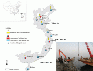
Coastal reclamation has expanded land resources and living spaces and contributed significantly to the economic growth and urbanization process in Netherlands, Japan, South Korea and China. From the 1950s to the 1990s China witnessed three important phases of coastal reclamation mainly for agriculture, salt production and mariculture. At that time over 30% of tidal land was reclaimed. After the 1990’s a new circle of coastal reclamation started to meet the needs of rapid urban expansion .According to an official report from China Oceanic Information Network in 2010 the authorized area of reclaimed land was 13 598 ha, accounting for 7 % of the nation’s sea use area that year .Current flourishing reclamation projects at national level include Tianjin new coastal district, Caofeidian Industrial Zone in Tangshan City of Hebei Province and the Yellow River Delta High efficiency Economic Zone in Dongying City of Shandong Province. The Bohai Bay is coming up as the hotspot for coastal reclamation in the coming decades after East and South. Compared with reclamation activities before the 1990s today’s projects are not only to enclose the tidal flats but also to fill in the wetland/coastal water bodies using civil materials. The reclaimed land has been constructed into harbor, seawall, industrial complex, urban district, which will permanently change the geomorphology of the coastal line and the physical processes of the coastal system, exerting even higher impacts on coastal environment and ecosystem. In certain scenarios natural interactions, such as the hydrodynamics and sediment processes, between land and sea have been seriously interrupted, leading to shortening of salinity gradient and increase of water eutrophication and pollution, which ultimately results in algae bloom, biodiversity decline and even seawater intrusion. Reclamation has increasingly emerged as a hot issue in coastal zones of China.
Gaps Remain In Environmental Monitoring
Several gaps remain in environmental monitoring after reclamation. Environmental monitoring should be focused on hydro morphology, eutrophication and pollution as well as organisms in the changing water and sediment systems.Reclamation activities in the Yellow River Delta were carried out mainly for oil industry hence the requirement should be on monitoring and assessment of the effects of oil pollution on seawater and sediments . Sample site investigation, spatial pattern of environmental changes must be identified to understand coastal ecosystem responses to the environmental changes at a large scale. Modern geospatial technologies, such as remote sensing and geographic information systems can provide alternative approaches. Time series remotely sensed images can be an ideal data source for retrieving the spatiotemporal information on water quality and soil conditions after reclamation revealing the underlying mechanism for environmental evolution after reclamation.
Coastal Development Legislation and Climate Change
The Chinese government has made significant efforts in developing legislation for coastal reclamation and in the year 2011 a national policy was formulated for planning of coastal reclamation projects. In pursuance of this policy several mangrove restoration projects have been initiated and proposed in Shenzhen, China. The revealing of the spatial distribution and temporal pattern of colonization of mangroves could contribute significantly to successful mangrove restoration projects. Reclamation confines the natural area to a narrowed stretch of beach exacerbated by sea level rise induced by global climate change and impact on harbors and navigation channels. Explicit models combined with global climate change models can be used to simulate the dynamic processes of coastal environments and identify further ecological succession of the reclaimed coastal ecosystems. Integrated studies to understand the trend of coastal development and predicting potential impacts of global sea level rise are wanting in reclamation projects in China . Port navigational channels draught is invariably affected by the diversion of ocean swells in monsoon season.Drainage of excessive urban waste water and run off water and at times rain waters may be blocked leading to massive urban flooding.
Authored by Nadir Mumtaz
Leave A Comment