
Hydrography & Monaco
The International Hydrographic Organization (IHO) is an intergovernmental organisation established in 1921 to promote cooperation among maritime nations in the field of hydrography and nautical charting. The IHO’s main objective is to ensure that all the world’s navigable waters are surveyed and charted to modern standards . The IHO is responsible for developing and promoting global standards for hydrographic surveys and nautical charting as well as for encouraging the dissemination of hydrographic information and the development of related technologies. The organisation works closely with national hydrographic offices, maritime organisations and the scientific community to achieve its goals. The IHO is headquartered in Monaco and has over 88 member states representing virtually all the world’s coastal states.
Digitising Hydrography
Hydrographic data enables digital management of marine resources, including fisheries and oil and gas reserves and supports environmental conservation efforts such as coastal zone management and marine spatial planning . An updated and accurate digital repository about water depths, tides, currents and the seafloor is of assistance in preventing marine disasters by forewarning about shoals, rocks and wrecks which are hazardous to shipping.
Digitising Charts
Modern day nautical charts are digitised and navigation is carried out through satellite link.The International Maritime Organization and national maritime authorities require ships to carry nautical charts complying to specific standards generated from digitised hydrographic data. The IMO’s International Convention for the Safety of Life at Sea (SOLAS) requires member states to survey, chart their waters and update charts to ensure safe navigation .
 Credit;CESCUBE
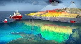
Hydrographic Survey
Hydrographic surveys identify areas of the sea bed abundant with minerals such as manganese nodules making deep-sea mining less cumbersome, internationally transparent and more environmental friendly. Accurate data on the seafloor and water column identifies sensitive habitats and areas of high biodiversity enabling informed marine spatial planning and conservation efforts. Hydrographic data can also support the monitoring and management of water quality, particularly in coastal areas where human activities can have a significant impact on the marine environment.
Military Application of Hydrography
Hydrography Surveys work through usage of multibeam echo sounders located beneath vessels and the sonar scans and bounces off seafloor enabling vital information on level of tides, currents, temperature and salinity to be digitally obtained and collated. Digital hydrographic data has strategic implications significant in the context of submarine navigation and underwater vessel designing. Accurate water depth and topography data is vital in developing anti-submarine warfare capabilities and identifying potential areas for submarine deployment. China continues to rigorously pursue an agenda involving regularly conducting hydrographic surveys in the Indian Ocean perhaps to enhance the operational perimeters of their submarines .
 Credit ; MDPL Hydrology
Hydrography is the Recent Scientific Buzzword
The National Oceanic and Atmospheric Administration (NOAA) describes Hydrography as the science that measures and describes the physical features of bodies of water. It is commonly bandied that only 5% of the ocean has been scientifically explored whereas exploration of space has been enormous. Climate change is nowadays closely tied to rise in the temperature of oceans.
Monsoon Patterns & Climate Change
The Indian Ocean remains the least charted oceans as revealed during the search for the missing Malaysian Airlines MH370 back in 2014 and some coastal states in the region rely on decades old charts. Seasonally reversing SAM (Indian or South Asian monsoon wind system) winds in the modern Indian Ocean (north of 10° S) drive surface waters from the southwest during May to September as the summer monsoon current (SMC).The reverse action ensues from the northeast during November to February as the winter monsoon current (WMC). The Himalayan orography acts as a thermal barrier and the shift in the Intertropical Convergence Zone with respect to the Indian Plate combined with the Himalaya and Tibetan Plateau’s topographical height mostly influencing the rainfall pattern. The Arabian Peninsula’s emergence triggered substantial upwelling in the Arabian Sea. Combination of these forcing factors and the consequent initiation of SAM wind system may have caused variations in the Indian Ocean surface circulation and thus mixed layer dynamics constraining the heat budget in the tropical Indian Ocean and its effect on regional and global climate.
 Credit;World-Atlas
Indian Ocean Warming is Alarming
The Indian Ocean is warming faster than any of the global oceans and its climate is uniquely driven by the presence of a landmass at low latitudes causing monsoonal winds and reversing currents which may be causing rise in sea levels with accompanying coastal erosion. Food, water and energy security in the Indian Ocean rim countries and islands are intrinsically tied to its climate with marine environment, ocean trade and logistics being an integral segment of their economic sustainability.
Regional Hydrographic Turf War
India is competing with China to chart international waters as well as the exclusive economic zones in the Indian Ocean . Smaller maritime nations are developing their own sovereign capabilities and control over information about their maritime domain. It is becoming increasing clear to all coastal states that hydrographic data is essential for naval operations whether surface vessels or submarines in the defense and security domain and offshore hydrocarbon exploration and seabed mining in the commercial or economic domain. India has made public its ambitions of becoming a regional provider of hydrographic services equipped with seven hydrographic vessels and has conducted approximately 100 foreign hydrographic surveys around the coasts of Maldives, Mauritius, Kenya, Tanzania, Myanmar, Sri Lanka and Seychelles . India has conducted training for around 800 foreign nationals from countries throughout the Indian Ocean, Asia and Africa.
China Counters Indian Hydrographic Influence
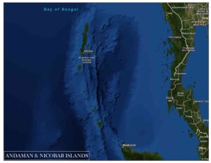
China has emerged as an alternative provider of hydrographic services to many countries operating around 30 oceanographic surveillance and research vessels many endowed with electronic surveillance capabilities against which allegations of espionage unfairly circulate. Regional coastal states remain wary of both Indian and Chinese offers of assistance of mapping of their marine areas of sensitive nature . India has expressed concern about China’s research activities in the Indian Ocean especially in the Bay of Bengal which is a sanctuary for India’s nuclear submarine fleet .
 Credit;fugro
Regional Hydrographic Feuds
A while back Maldives opted against renewing an agreement with India for conducting of hydrographic surveys of Maldives waters and subsequently Maldives inked a defense cooperation agreement with China. A Chinese research vessel Xiang Hang Yang docked in the Maldives after undertaking three weeks of hydrographic surveys just outside the exclusive economic zones of Maldives, Sri Lanka and India. The location of the survey lends credence to the assumption that the survey was carried out to facilitate any future People’s Liberation Army Navy submarine and anti-submarine operations. To build up Maldives hydrographic survey capacity China may consider to establish a marine research station in the north of Maldives.
India teams up with Western Countries
The North Indian Ocean Hydrographic Commission (NIOHC) was established in 2002 as the 13th Regional Hydrographic Commission with Bangladesh, India, Myanmar, Sri Lanka, Thailand and UK as initial members, with 03 associate member countries and 03 observer countries to promote greater navigational safety in the Indian Ocean region through common standards and procedures. The area of NIOHC covers the northern part of Indian Ocean from Andaman seas to Gulf of Aden excluding the Gulf of Oman area. A large portion of the world’s maritime traffic passes through the area.
Politics of Hydrography
The scientific purpose of mapping out sea floors is to keep maritime operations a seamless process. Geopolitically financially dependent economies remain vulnerable to loss of sovereignty to economic giants in the Indian Ocean such as China and India. Exclusive Economic Zones (EEZs) of low income nations are regularly encroached upon and the West alleges that China uses the economic clout of the Belt Road Initiative (BRI) as leverage to trap smaller nations to access EEZ beyond its jurisdiction. After Sri Lanka terminated hydrographic services conducted by foreign research vessels China turned to Maldives vast maritime jurisdiction shortly after Maldives terminated agreement with India for conducting hydrographic surveys.
Role of IGOs
Members of South West Pacific Hydrographic Commission (SWPHC) are convincing coastal states to share marine spatial data ostensibly to develop a global digital or e platform and so far the International Maritime Organization and the United Nations Convention on the Law of the Sea have not held any meaningful dialogue in this domain .
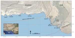
Pakistan’s Coastline
Pakistan’s coastline stretches up to 1120 km spread along the Sindh and Balochistan provinces with the Arabian Sea lapping at its coast .Around 348 km of the coast lies within the province of Sindh . Pakistan’s coastal belt extends in the West from Iran at Jiwani to its Eastern border with India at Sir Creek , across two coastal provinces of Balochistan and Sindh .The Sindh coastline is comprised of the Karachi and Indus Delta regions boasting of two ports namely Karachi Port and Bin Qasim Port. The low-lying Indus Delta region covers an area of approximately 60,000 km2 stretching around 210 km where it meets the sea containing around 94% of Pakistan’s mangroves which is steadily being encroached in connivance with local authorities. The Indus Delta exhibits ongoing challenges due to upstream water management interventions which have affected water and sediment flow across the delta and driven river flooding, erosion, saltwater intrusion, activities such as land reclamation, disposal of solid waste and non treatment of industrial effluent and sewage. These intervention place the province of Sindh at higher risk from the impacts of sea-level rise than Balochistan . The coast is extremely vulnerable to erosion . The ship re-cycling industry in the province of Balochistan active is impeding longshore movement of seawater and sediment thereby increasing erosion. Unplanned construction of a plethora of fishing jetties is blocking tidal movement leading to silting and sedimentation which is disastrous to navigation and depletes fish stocks as well . Tide gauges in Pakistan are located at Karachi coast (data available from 1916), Ormara, Gwadar, and Keti Bandar. The tide gauges at Keti Bandar, Gwadar and Ormara are under the management of the Pakistan Navy Hydrographic Department whilst the Karachi tide gauge is managed by Karachi Port Trust.
Flooding
Massive engineering projects especially the Left Bank Outfall Drain (LBOD) have impacted sediment budget across the delta causing widespread river flooding in the province of Sindh. The vulnerability and exposure of the Indus delta was evident from widespread river flooding which occurred in the years 2010 and 2022 following heavy monsoon rainfall. Specifically the 2010 flooding is attributable to dam and barrage influenced backwater effects, reduced water and sediment conveyance capacity and multiple failures of irrigation system levees. As a consequence of reduced sediment and water transport in the Indus Delta towards the coast the number of distributary channels has significantly reduced from 17 channels in 1861 to just 1 significant channel in the year 2000 and the rate of aggradation has become insufficient to keep up with local sea-level rise which does not allow monsoon induced torrents to flow into the sea . Pakistan desperately needs to establish an Enabling Policy Environment by Integrating Coastal Climate Services into the National Adaptation Plan and Developing a National Framework for Climate Services.
Authored by Nadir Mumtaz, Researcher Razeen Ahmed
Credit /Source
https://www.scribd.com/document/323949016/Coastal-Erosion-in-Pakistan
https://www.lowyinstitute.org/the-interpreter/mapping-oceans-new-front-battle-influence-indian-ocean
https://www.mdpi.com/2306-5338/10/11/205
https://ukhodigital.blog.gov.uk/2023/07/13/why-should-we-share-data/
https://www.frontiersin.org/articles/10.3389/fmars.2019.00355/full
https://www.sciencedirect.com/science/article/abs/pii/S0921818123003090
https://iho.int/en/north-indian-ocean-hc
Leave A Comment