
Han River Major Water Source
 Credit ; Korean Institute of Public Administration
The Han River serves as a major water source for South Korea despite environmental concerns as industrial effluents are dumped into the river .
Origin
 Credit : Korean Institute of Public Administration
The Han River emerges as two small rivers in the eastern mountains of the Korean peninsula converging near Seoul and was once a trade conduit to China through the Yellow Sea.
Nautical Charts
 Credit : YONHAP NEWS AGENCY
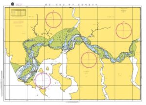
Access to the Han River and Imjin River estuaries was restricted ever since the Korean Armistice Agreement was signed in 1953. Under the Armistice Agreement private vessels from both Koreas are granted free passage in the estuary. Preparation of nautical charts is likely to allow a maritime route that can be navigated by vessels from South Korea and North Korea. Four years back nautical charts were prepared in order to enable South and North Korean vessels to navigate the estuaries.
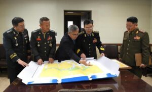
 Credit : HANKYOREH
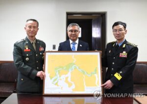
South Korea’s Ministry of National Defense has publicly informed that it had sent the North Korean military nautical charts , composed and based on the findings of a joint inter-Korean hydrographic survey carried out at the end of 2018 along with a report on the survey’s findings. These nautical charts contain information which are a pre-requisite for shared use of the river waters by North Korean and South Korean vessels providing relevant information about water depth, coastline and submerged rocks.
 Credit: HANKYOREH
In the first stage on trial basis free passage in the estuary for private vessels was to be permitted in accordance with the provisions of the 2018 military agreement to be gradually expanded in stages.
Industrial Pollution & Potassium Cyanide
The river provides water for over 12 million Koreans and protests were made when in the year 2000 , the US military admitted to having spilled toxic chemicals in the river. In the last 8 years many companies were found to be discharging wastewater polluted with hazardous chemicals including potassium cyanide, chromium, lead, copper and phenol into the river.
Navigation & Transport in the Han River
The 38th latitude line, which divided the peninsula at the end of the Second World War, ran north of Gaeseong and the estuary of the Han River where it drains into the Yellow Sea being well within South Korean territory. At that time shallow draft vessels could sail from the ocean right up to the shores of the city however the Korean War left the dividing line several kilometers further South than the 39th parallel. As the North bank of the estuary Westwards has lain within North Korea turning the waters into a no-go zone flowing in a weapon controlled area ceasing navigation to and from the sea . Inland waterways development along the Han River would greatly reduce Carbon Footprint in South Korea .
Recent Studies analyse Possibility of Inland Navigation in Han River
A recent study has analysed the possibility of inland navigation in the Han river mouth commencing from the Singok weir to the junction of Gongleung Stream. As a result of analysis using recent survey data and water level data it was found that the number of days that a 250 – 400 ton class vessel can operate in the Han River estuary is less than 119 days per year. In the case of a 400 – 1,500 ton class vessel it was concluded that the operational period is 47 days. Although no large scale flooding takes place the river bed continues to change significantly due to strong tides indicating that there are limitations in securing a stable waterway. It was postulated that for stable inland navigation further investigation and analysis of the possibility and stability of waterways was necessary.
Flooding in Han River
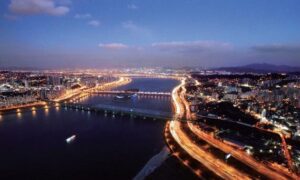
Centuries of soil erosion from the mountain ranges over the upper reaches of both the South and North Han Rivers had deposited grit and gravel downstream so that the riverbed became flatter and wider. The additional quantity of water that descended in the monsoons was too much for the shallow basin to cope with resulting in widespread flooding and till the 1970’s Han River posed a barrier to development. However rapid rise in prosperity in Gangnam (South-of-the river zone) district led to a frenzy of bridge building across the Han River.
Olympics & Deepening of Han River
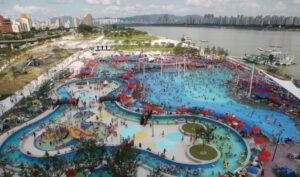
The Han River Ferry cruises are a source of local entertainment . The Olympic Games led to construction of a riverside highway raised high enough to avoid flooding which , at the same time, raised the river banks and deepened the river thereby increasing flow of water. Massive dredging projects were carried out and touristic entertainment spots established .To keep the banks from overflowing and protecting the highways, commercial and residential estates a flood control system was created with a barrage across the river designed to adjust the flow of seasonal water .
China & Seoul’s Direct Maritime Connection
The Han River Renaissance Project envisages burying of the highways on either bank. In the longer run the long-awaited Gyeongin canal connecting the Han River and the West Sea emerging south of Gangwha Island and north of Incheon may provide a vital maritime link between Seoul and the ocean. Such a maritime logistic link may allow shallow draft sea-going vessels, low in height , to sail all the way from China to the center of Seoul.
Authored by Nadir Mumtaz
Sources: Credit
https://www.jeri.or.kr/articles/article/jXvY/
https://english.hani.co.kr/arti/english_edition/e_national/880735
https://www.eemodelingsystem.com/modeling-resources/free-grids/han-river-south-korea
https://www.kipa.re.kr/site/eng/research/selectKoreaView.do?id=95&seqno=1053
https://en.yna.co.kr/view/PYH20190130140700315
Leave A Comment