International Hydrographic Organization introduces modernised Hydrographic Geospatial data standard
To break away from the fixed and inflexible architecture of S-57, the International Hydrographic Organization (IHO) is introducing an advanced hydrographic geospatial data standard to the maritime industry. This new data framework is known as S-100 and provides enhanced support in managing a wider variety of information and data , now available on account of modern technologies and seamless data exchange. The S-100 has been developed by the International Hydrographic Organization and is a universal data framework that will enrich and enhance the way maritime data is collected, shared and utilised. The data framework has the potential to bring tangible benefits to a broad spectrum of maritime stakeholders from improving navigational safety to enhancing efficiencies in support of decarbonisation across the industry.
 Credit ; Vanessa Blake,CEO UK Hydrography Office
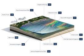
By enabling a wider array of interoperable data sets to be displayed on ECDIS the S-100 will ensure a comprehensive digital perspective of the marine environment empowering stakeholders to make better informed decisions. The transition to S-100 will enable maritime cyber security though sophisticated data validation and integrity checks as the existing S-57 remains susceptible to cyber breach. The integration of dynamic data layers such as real- time tidal information and high-resolution bathymetry will facilitate safer navigation through increasingly complex waterways.
Autonomous and remotely controlled vessels
Designed with future technological advancements in mind, S-100 standards will also ensure compatibility with emerging technologies such as autonomous and remotely controlled vessels to support safe navigation for the looming maritime technological revolution . As maritime communication advances semi-autonomous and remotely operated vessels the drawback of the S-57 data is prominent as it was meant for human interpretation .
Digital Transition
There is expected to be a crossover period between the adoption of S-101 (the product specification for ENCs) and the retirement of S-57. Eventually, all legacy S-57 products will be replaced with S-101. In the meantime, the IHO has introduced the concept of a ‘dual-fuel mode’ to enable systems to process data from both S-57 and S-101 despite the target of year 2026 to introduce the IMO’s performance standard for S-101, as it will not be mandatory by this point to use S-101 ENC data. The S-104 and S-111 will provide additional digitised data on tidal and surface currents. Giving a mariner or fleet superintendent access to more precise and accurate water level and depths information will empower them to make more digital and instant data-driven decisions that take into account shallow waters or changes in tides. As a result of the real- time data transfer, mariners will be able to detect as to how changes in tides might affect their ETA and they can initiate action to avoid this. As an illustration if a tidal current changes and the vessel’s speed is accelerated or decelerated, its ETA will change. The S-57 data however does not support real-time data integration or high-resolution updates and continues to provide general information about tidal currents and does not offer the dynamic, precise, and forecasted tidal current data that modern mariners require for optimising routes and ETAs. With S-100 framework enabled products navigators will have access to this data in real time allowing them to make a decision introducing a certain degree of predictability for vessel in adhering to its intended ETA, whether that’s speeding up, slowing down, or rerouting.
 Credit;Admiralty
Significantly for ports this enhanced data implies that if the vessel fails to adhere to its ETA, the port knows in advance and can make adjustments to berthing schedules to avoid empty berths or idling ships both which mean financial losses .
Navigational Safety
The more space a vessel has between itself and the coastline the safer the passage and the lesser the risk of grounding or a collision .In shallow or congested and complex areas like ports ,channels and coastal areas a lack of detailed bathymetric contours impedes safe navigation as mariners cannot access granular data and information about the seafloors bathymetry . The S-57 may not offer enough granularity about the Panama depth levels being slashed for navigational safety , attributable to climate changes , and mariners do not have access to real time data for route planning and even small changes in the water depth may impact navigational safety . If the depth between two contours jumps by 5 m to 10 m it creates difficulty in calculating the UKC and margin for safe vessel transit can be compromised. Areas deemed safe or unsafe for vessels to navigate are determined by safety contours on an ECDIS (Under Water Clearance). Presently S-57 data is used by around 50,000 ships and does not provide accurate real time data in planning routes and managing real time ETA’.
Demurrage
Shipping lines were charging ( $ 2638 for two weeks on a single container ) high demurrage fees at the Port of Long Beach and Port of Los Angeles at the peak of severe port congestion in the year 2021 .The financial impact of port congestion is huge and the fuel costs for idling for container ships and tankers may vary from USD $ 50,000 to 100,000 per day . Ships idling at ports also cause biofueling and carbon emissions.
Cyber Logistics is the New Frontier
A vessel with a larger TEU will need highly accurate UKC measurements because of its deeper draft as there are more risks involved. Ports with shallow waters may not be able to accommodate such vessels. It is forecast that owing to the greater insight on dynamic water environments that the S-100 products will supply, there will be opportunity for vessels containing large TEU’s to access ports that they were unable to call at previously. A ship with a greater TEU will carry more containers per voyage, directly increasing the potential revenue from each voyage. Simplistically the more cargo a ship transports the more revenue it generates. Additional dollars can be earned by loading more containers onto a container ship. Furthermore, larger volumes of cargo allow shipping companies to offer more competitive rates or enter into favourable long-term contracts with clients, attracting more transportation and logistics business. Safer and efficient navigation through harbours and ports is expected to affect vessels’ insurance premiums and lower transportation costs . Cyber Logistics is the New Frontier.
S-100 and Shipping Profits
 Credit;UK Hydrographic Office
Large Container /TEU Ships
The latest trend is for construction of larger vessels . Traditionally most vessels were hovering around the 10,000 TEU mark, but in 2013 the global shipping line Maersk set a new record, deploying its 13,000 TEU E-Class vessels and subsequently its 18,000 TEU vessels. This move catalysed the emergence of large container ships. Increasing the UKC to allow for a higher TEU, either by lengthening the vessel or widening the beam to add more containers allows more profitability to be derived from a container ship . Calculations depict that a 400 m long vessel could carry 97 additional TEU with a 10cm increase in UKC. With a profit per TEU of US $70, the additional 10cm UKC would increase the profit by a hefty $6,790 . Another scenario where the profit per TEU is US $140, the increase of 10cm UKC would bring a staggering $13,677 profit , for the same number of 97 TEU’s. Although freight rates constantly change with an additional 10cm of UKC a vessel of 400m length could carry around an additional 100 TEU’s reflected in increased profits on voyages by at least 0.5 % per 10cm of UKC, providing ample incentive to deploy digitally advanced and improved safety contours. No doubt the profit per TEU significantly affects the additional profit. At a higher profit margin per TEU ($ 141 compared to $ 70) those mariners or fleet supervisors adopting S-100 navigation would oust competitors as minor increase (10cm) in UKC rakes in profits, particularly with larger vessels of length of 400m as compared with a ship of length of 250m.
Author ; Nadir Mumtaz
Trademark Blue Economy IPO-PK
Credit:
Fiona MacDonald
https://www.gov.uk/government/organisations/uk-hydrographic-office
Leave A Comment