
Sir Creek Indian Maritime Obduracy
Sir Creek , a fluctuating tidal channel or estuary is 90 km long , situated in the marshes of the Rann of Kutch on the border between the Indian state of Gujarat and Pakistan’s province of Sind. The presence of a large yet antiquated naval fleet maintains India’s euphoric self-deceptive confidence amidst the forlorn hope that it can engage Pakistan in the maritime arena of Sir Creek . India continues with militarisation of the Sir Creek area establishing numerous fixed and Floating Border Outposts , inducting Coast Guard and Navy units emboldening it to posture towards realising its obscure trans-frontier objectives. Surreptitiously and insidiously infrastructure expansion by the Border Roads Organisation has connected forward posts, while the Indian Air Force bases at Naliya, Bhuj and Jamnagar alongside the new Sardar Patel Naval Base, ostensibly provide depth and permanence to this overt militarisation.

Credit;DGPR-PakistanNavy
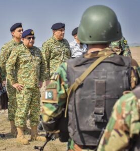
Pakistan’s Maritime Resolve
Consistent with its principled stand of solely safeguarding its territorial sovereignty and promoting regional peace and development to improve the quality of life of the people of South Asia Pakistan retains a purely defensive military presence in the creeks . The Pakistan Navy , acclaimed worldwide for its professionalism , maintains the 301 Creeks Brigade, a specialised formation of Pakistan Navy Marines explicitly tasked with defending territorial maritime integrity. Any cross border maritime intrusion or misadventure by its trigger happy neighbour India will be countered by Pakistan . To convey combat readiness and resolve to counter any external threat Chief of the Pakistan Naval Staff, Admiral Naveed Ashraf conducted a visit of forward posts in the Creeks Area to review combat operational preparedness and witnessed the induction of three state-of-the-art 2400 TD Hovercraft into Pak Marines .


Credit;DGPR-PakistanNavy
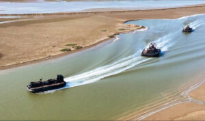
These newly inducted state of the art Hovercraft are capable of simultaneously operating over a variety of surfaces, including shallow waters, sand dunes, marshy and boggy littoral zones and can ply in areas where traditional craft are neither suitable nor designed to operate. This unique capability of undertaking simultaneous operations over land and sea make the Pakistan Navy capabilities formidable .

Credit – Pakistan Navy DGPR-Navy
India Flogging a Dead Horse
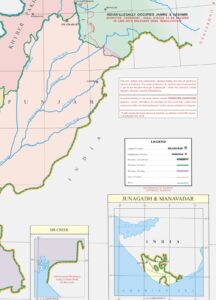
The origin of the dispute can be traced back to Resolution 1192 of 1914, signed between the Bombay Presidency (on behalf of Kutch) and the Government of Sindh. After surveys and arbitration, this resolution explicitly demarcated the Sindh–Kutch boundary along the eastern bank of Sir Creek which inexplicably India fails to appreciate. The dispute over Sir Creek can be traced back to the pre-independence period, to around 1908, when an argument ensued between the rulers of Kutch and Sind over a pile of firewood on the banks of a creek dividing the two principalities. The dispute was resolved in 1914 supported by Map Number B44 and subsequently B74.1 . One fine day India raised a dispute , in the 1960s. Driven and consumed by war mongering hysteria after being exposed and outwitted by the Pakistan military this year , India is stoking buried conflicts such as Sir Creek and Tulbul/Wular navigation in Kashmir .
Indo-Pakistani Western Boundary Case Tribunal
In 1965 after armed clashes Pakistan rightly asserted that half of the Rann along the 24th parallel was Pakistani territory whereas India remained obdurate and countered that the boundary ran roughly along the northern edge of the Rann. The matter was referred to international tribunal for arbitration with the Indo-Pakistani Western Boundary Case Tribunal announcing its Award on 19th February 1968 upholding a substantial segment of India’s claim to the entire Rann, whilst conceding relatively less sectors to Pakistan. The Indo–Pakistani Western Boundary Case Tribunal (1966–1968) comprised judges from Iran, Sweden and Yugoslavia (the latter serving as chair) however the tribunal refrained from ruling on the Sir Creek issue, deeming it beyond its mandate only demarcating the land boundary up to the top of Sir Creek (known as Boundary Pillar 1175).
Pakistan Navy Hovercraft Patrolling its Maritime Territory & EEZ in Sir Creek
 Credit;ArabNews
The Sir Creek dispute originated after the parties had agreed before the tribunal to limit their larger dispute over the Rann to the boundary in the north. Well to the south lay an agreed boundary that began at the head of Sir Creek and ran a short distance eastward roughly along the 24th parallel yet India irrationally contends that this line moves up sharply at a right angle to meet the northern boundary of the Rann. In the words of a seasoned Pakistani diplomat the dispute hinged on the demarcation of the boundary from “the mouth of Sir Creek to the top of Sir Creek” and from “the top of the Sir Creek eastwards to a point (on land) designated as the Western Terminus.” Prior to approaching the International Tribunal both parties had agreed to exclude the boundary from the head of Sir Creek downward to the west, right up to the mouth of the creek on the Arabian Sea. Understandably the adjudicators in 1968 did not discuss the Sir Creek because in the pre-partition documents the creek was clearly indicated as in Sind which is now in Pakistan.
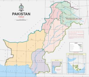
Credit;Survey of Pakistan
Composite Dialogue Process
India and Pakistan have so far held 6 rounds of discussions on the dispute but India refuses to listen to reason and internationally recognised principles of maritime delimitation and insists, in defiance of the 1914 award, that the boundary lies in the middle of Sir Creek. The Resolution 1192 of 1914, signed between the Bombay Presidency (on behalf of Kutch) and the Government of Sindh concluded after surveys and arbitration clearly supports Pakistan’s position that the line lies on the Creek’s eastern bank therefore the entire Sir Creek is Pakistan’s maritime territory .
Navigation & Tides
What India perhaps deliberately , fails to understand is that mid- channels of the Creek shifts frequently depending on the pattern of the tides. This remains a worldwide tidal phenomena of creeks involving concepts of “equidistance” and “equity” in delimiting maritime boundaries from the mouth of creeks towards the open seas. While the Sir Creek issue has been settled as far back as 1914 India naively proposed in 1994 that the delineation of the maritime boundary in the territorial sea be governed by the ‘median / equidistant’ principle’, using the low water lines and low tide elevations of both countries, whereas beyond the territorial sea it could be governed by ‘equidistant’ as well as ‘equitable’ principles. This proposal of India is self contradictory and self-defeating as well. Responding to this naïve and illogical proposal, on 10th September 1996, Pakistan made a declaration that straight baselines should be drawn along its coast, consisting of a series of 9 straight lines which India displaying its typical and traditional stubbornness rejected by stating that these lines are not in accordance with Article 7(2) of the UN Convention on the Law of the Sea. India also objected to the fact that Point K in Pakistan’s straight baselines system lies off the eastern bank of Sir Creek. To some extent India and Pakistan are in agreement on the horizontal sector of the land boundary and agree to delimitation of a boundary line by existing boundary pillars along the horizontal line and fixation of intermediary pillars in the same line which encompasses the international boundary between India and Pakistan on the land, in the Rann of Kutch area demarcated on the basis of the Tribunal’s Award of 1968. In September 1998 India and Pakistan agreed to form separate working groups for the Sir Creek dispute. Each issue was to be taken up by its concerned working group as part of a composite dialogue process. The talks of the Sir Creek working group were ultimately held on 8th November 1998 in New Delhi. Pakistan, while agreeing that the boundary along the horizontal line and in Sir Creek was a settled issue, maintains that in its interpretation the Green Line (denoting the eastern edge of the Creek) of the map, appended to the 1914 Resolution and should therefore, be transposed on to the ground and accepted by India.
US Riverine Force and Drug Cartels
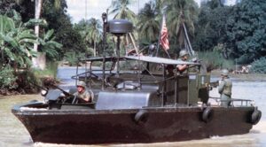 Credit;CIMSEC
As a consequence of the US Navy’s transition from its War on Terror-era strategy and the rise of military China, its riverine capabilities were relegated to a secondary place in its operational design. After witnessing heavy use in Iraq, the former Coastal Riverine Force which was mainly dedicated to riverine, littoral and harbor security operations has been renamed as the Maritime Expeditionary Security Force (MESF) to reflect the US Navy’s vision of its increasing blue-water integration. The Mobile Riverine Force was initially a joint Army-Navy venture formed during the Vietnam War. A not so well illustrated segment of the Vietnam War witnessed US soldiers and sailors working together in the Mekong Delta of South Vietnam to dominate the fluvial local terrain comprising of rivers, streams and swampy rice paddies. Brown-water fleets have served a number of strategic roles in their history as roads could be washed out with rain and railroads torn up by insurgents yet rivers proved to be consistently reliable lines of communication , relatively secure from bombardment. Inland waterways played a major role in Vietnam and Iraq as a means of fighting against irregular warfare by conducting regular patrols along Vietnam’s extensive network of deltas. In Vietnam around 500 riverine craft and 7000 sailors were deployed. Riverine tactics are being utilised by both sides in the Russian – Ukraine War in a variety of ways .The US President Donald Trump crusade in combating drug cartels in Latin America operating beyond coastal regions requires performing of reconnaissance in areas where dense forest cover prevents aerial surveillance of illicit drug transportation. Creating of naval jobs , comprising of contractual civilians as in the US Navy, would extend the traditional influence of the Navy away from the coasts and into regions typically isolated from the impacts of maritime policy.
Pakistan’s EEZ Expansion
Credit;Survey of Pakistan
With a view to exploiting maritime resources which it is not legally entitled to India insists to consider the delimitation of the India-Pakistan maritime boundary from the seaward side, by commencing at Exclusive Economic Zones (EEZ) limit and proceeding landwards up to a mutually acceptable limit according to the provisions of the Technical Aspects of Law of Sea (TALOS). Pakistan is at an advantageous position as it has carried out hydrographic survey of the Sir Creek and follows internationally accepted cartographic procedures . The Pakistani EEZ will be enlarged by around 250 square miles when India accepts the Green Line showing Sir Creek’s eastern bank as the land boundary . To exploit the rich hydrocarbon and mineral resources of Sir Creek Pakistan should ensure that the mangrove forests are not endangered and no private concrete estates are developed in this marine ecosystems as being done in Korangi Creek. Pakistan’s rejects the mid-channel principle as it applies only to ‘navigable channels’ and Sir Creek is non-navigable nor conducive for commercial use. Indian asserts that the channel could be used for navigation during the entire year especially during high tides which implies that the channels are not navigable in low tide phenomena and non monsoon season. On account of India’s pettiness after 8 rounds of talks, the dispute persists as India pursues an intractable stance.
By Nadir Mumtaz
Blue Economy Trademark (IPO)
Credit ;
https://www.surveyofpakistan.gov.pk/
https://www.surveyofpakistan.gov.pk/SiteImage/Misc/files/political_map_pakistan.pdf
https://www.thefridaytimes.com/08-Oct-2025/india-provokes-new-flashpoint-sir-creek-gambit-pakistan
https://www.thefridaytimes.com/08-Oct-2025/india-provokes-new-flashpoint-sir-creek-gambit-pakistan
https://www.nation.com.pk/06-Oct-2025/sir-creek-settled-boundary-unsettled-dispute
https://www.nation.com.pk/06-Oct-2025/sir-creek-settled-boundary-unsettled-dispute
https://www.dawn.com/news/1951253/naval-chief-reviews-operational-preparedness-in-creeks-area
https://cimsec.org/mobile-riverine-force-example-riverine-ops-21st-century/
Leave A Comment