
Commercial & Military Maritime Application of AI & Digital Technology
Unmanned Hydrographic Vessels and AI
Replacing Manpower & Dock Labour
China’s Qingdao Port has initiated an automated mooring system which relies upon vacuum technology.This year the port handled a container ship of 16,000 TEU capacity in an unmanned operation which took around 30 seconds. The process utilises 13 advanced vacuum machines. Earlier the time required for mooring was 20 to 30 minutes. Unlike traditional mooring operations, no workers were involved in securing of the mooring lines as the system automatically positioned the vessel after identifying it and using the vacuum suction pads to attach to its hull . The automated design has a real-time monitoring framework which continuously monitors current, wind and wave conditions, allowing for intelligent active stabilisation control and automated hover suction. The Shandong Port Group claims that automated mooring will save over 200 hours of mooring time annually and increasing berth productivity by berthing 10 additional ultra-large vessels .
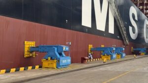 Credit;SPG
AI-based technologies being tested
AI and Mathematical models are no doubt powerful, yet their reliability must be validated and demonstrated using calibration points. Artificial Intelligence cannot emulate and learn properly if it cannot rely on observations that represent reality. In the commercial shipping world, AI-based technologies are about to be tested, resulting in additional bathymetry and hydrography needs that will eventually become necessary and critical.
Autonomous Prototypes
Commercial Marine Autonomous Surface Ships (MASS) such as the ‘Rolls Royce-Kongsberg’ are prototypes in development and will eventually be tested in Europe . Norway is an undisputed leader in the Maritime AI domain. Such commercial MASS are perceived as economical in terms of fuel consumption, optimisation of transportation routes, reduction of greenhouse gas emissions and reduced risks to navigation by adhering to a plethora of rigid navigation criteria .
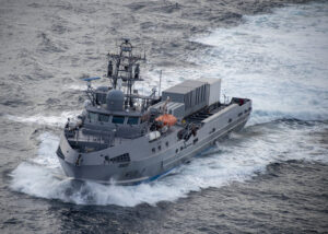 Credit;USNI
Hydrography & Terabytes
Hydrographic offices are collecting hundreds of terabytes of data emanating from bathymetry data sensors, weather stations, radar, ships, satellites, aerial and drone imagery and other sensors. A technology known as GeoAI, the intersection of spatial data and artificial intelligence automate time consuming processes and adopt modern technologies. Data collected from multibeam echo sounders can be analysed to update ENCs by detecting new obstructions such as rocks and shipwrecks. Using that same point cloud, GeoAI can then be used to understand marine animal habitat by identifying underwater structures and seafloor patterns that lead to increased biodiversity. GeoAI can be used to aid in coastal resilience projects by analyzing aerial imagery from drones captured in multiple seasons and years for change detection in order to highlight vulnerable and exposed areas.
Real Maritime Vs AI
Autonomy is impressive in a laboratory or controlled environment with a stable internet or network and fine weather .However the
ocean can rudely ignore assumptions, algorithm and successfully tested prototypes. Hydrographic surveying is changing fast. Not because the seabed moved but because the survey vessel did which is no longer crewed . The International Hydrographic Organization (IHO) defines the global benchmarks that hydrographic data must meet to be trusted for navigation, planning and maritime safety. These requirements apply equally to crewed ships and uncrewed platforms. A multibeam mounted on a USV is still judged by the same uncertainty budgets, coverage requirements and feature detection criteria as any other survey system. While autonomy removes crews from vessels it does not remove responsibility for the data. Pivotal to this framework is IHO Publication S-44 specifying the minimum standards for hydrographic surveys and defines what “fit for purpose” really means. For Unmanned Surface Vehicles (USV) operators, system integrators and end users, S-44 is the reference that turns autonomy from an experiment into an accepted and valid operational tool.
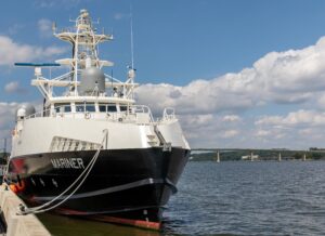 Credit;USNI
Unmanned Surface Vehicles now operate in place of large vessels, full crews and long mobilizations. Ports, Coastal waters , Shallow approaches and Restricted areas are being mapped by UAVs quietly, efficiently and with a level of repeatability that traditional platforms struggle to match. Autonomy does not relax standards instead it makes them rigorous requiring relentless data flows and analysis.
Seabed Dosent Forgive
A few decimeters of error from a USV is just as dangerous as a few decimeters from a crewed ship. The seabed does not care how modern the platform looks hence S-44 is the distinction between experimentation and operational credibility. It determines whether data is chart-ready or just visually impressive. It tells us when full seafloor search is mandatory, when generalisation is allowed and when calibration errors consume the entire uncertainty budget.
Military Application of AI
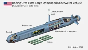 Credit;Forbes
Modern sea mines are shrinking in size, reducing acoustic signatures and deliberately blending into seabed clutter. Sea warfare is undergoing a rapid transformation and its not about new hulls, exotic propulsion or faster minehunters instead focuses on sensors, autonomy and unmanned systems ensuring crews remain out of the danger zone. Modern Mine Countermeasures rely on USVs towing high-resolution sonar, executing autonomous search patterns and feeding AI-assisted classification pipelines. While modern sonar systems are designed to detect faint acoustic returns such heigtened sensitivity produces a flood of detections. Natural rocks, discarded debris and seabed features all generate returns that initially appear suspicious invariably flagged as Mine-Like Echoes (MILECs) . Unmanned underwater vehicles (UUV) possess autonomy and flexibility equipped with mines , either in a stationary and moored position underwater or able to propel mines while keeping the launch platform and crews safe from detection.
 Credit;SIMSEC
UNCLOS Jurisdictions and AI
Regulatory oversight , conflicting maritime security and economic interests of maritime nations and an international legal framework have to be harmonised prior to navigating the Law of the Sea and Ports resulting from the Impact of Technologies in the Maritime Sector and Navigation Law . The rise of Maritime Autonomous Surface Ships (MASS) is throwing up new regulatory and liability issues as international legal frameworks are vague in this regard.
Digitally Accessible Ocean
The General Maritime Directorate of Colombia (DIMAR) and the Catholic University of Colombia developed an “Accessible Ocean” to provide timely information to those interested in developing maritime activities in Colombian coastal zones through Big Data analysis.
Author;Nadir Mumtaz
Trademark Blue Economy (IPO)
![]()
Credit;
https://www.lmitac.com/news/chinas-first-vacuum-based-mooring-system
https://ihr.iho.int/articles/unlock-insights-from-hydrographic-datawith-geoai/
https://doi.org/10.5194/egusphere-2025-904 DOI 10.63028/10067/2117290151162165141
https://doi.org/10.1007/978-3-032-08664-8_13
https://www.linkedin.com/in/thomasmeurling/recent-activity/all/
https://www.hydro-international.com/content/article/the-emergence-of-ai-in-the-hydrography-sector
https://ihr.iho.int/articles/unlock-insights-from-hydrographic-datawith-geoai/
http://regional.chinadaily.com.cn/ensd-port/2026-01/05/c_1152827.htm
Leave A Comment