Ocean Data & Maritime Sovereignty
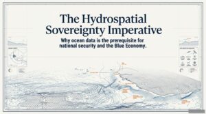
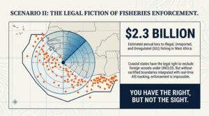
Ocean data is a prerequisite for maritime sovereignty and Blue Economy and states have the legal right to exclude foreign vessels under UNCLOS . Without boundaries integrated with real-time AIS tracking enforcement is impossible. Senegal is sitting on one of the most valuable maritime domains in West Africa possessing 212,000 square km of Exclusive Economic Zone (EEZ). Senegal boasts some of the most productive fishing grounds on the Atlantic coast , confirmed oil production at Sangomar and an estimated 15 trillion cubic feet (tcf) of natural gas at the Greater Tortue Ahmeyim field straddling its maritime boundary with Mauritania.The deepwater field extracts crude via a floating production, storage and offloading (FPSO) facility named the Léopold Sédar Senghor , yielding roughly 100,000 bpd. The Greater Tortue Ahmeyim Phase 1 (operated by BP) may establish the basin as a world-class gas province and a major LNG hub. Senegal is is not a poor country’s ocean. instead it is an extraordinarily rich maritime domain however , the reality is that hydrospatial coverage of Senegal waters remains incomplete by international hydrographic standards.
Informational Dependence
Countries negotiate own resources from a position of informational dependence. When illegal fishing fleets operate in waters at enormous cost to fishing communities, enforcement requires maritime domain awareness which needs to be built . Pakistan has around 45,000 registered fishing vessels and boats , yet these boats are reluctant to deploy AIS tracking or GPS.
Maritime Boundary on Paper
Pakistan is almost 4-5 times the size of Senegal and its population is almost 12 times more compared to Senegal’s population . The coastline of Pakistan is almost double that of Senegal . This is the hydrospatial sovereignty gap and it has significant economic, legal and security consequences. A maritime boundary on paper is meaningless without the certified hydrographic data to enforce, defend and leverage it.
Hydrographic as Sovereign Instrument
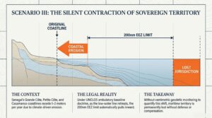
This is precisely where hydrographic and geophysical expertise becomes a sovereign instrument. Multi-sensor survey operations integrating Multibeam Echo Sounders, Side-Scan Sonar, Sub-Bottom Profilers and GNSS-RTK positioning deliver centimetric precision on seafloor morphology, sediment structure, coastal baseline displacement and subsidence rates. This is not laboratory science but field-validated, operationally deployed knowledge that tells a state exactly what it owns, where its boundaries stand, how fast its coastline is retreating, and what lies beneath the waters it claims. That expertise, when institutionalized at the national level and governed as sovereign data infrastructure, transforms a legal entitlement into an operational reality. Silent contraction of maritime sovereignty is a reality , unless ocean data is acquired.
National Nautical Survey Policies
Australia has devised a national policy to survey every nautical mile of its maritime jurisdiction. Norway mapped its entire continental shelf and used that data to extend its sovereign territory through the CLCS process.
These countries understood something fundamental that ocean data is not a technical support function. It is the operational foundation of national sovereignty at sea. Pakistan needs to construct its hydrospatial governance capacity to claim its 290,000 sq km of EEZ on its own terms. A country cannot defend what it cannot measure. You cannot govern what you cannot see.
Authored by; Nadir Mumtaz

Credit;
Seydouna Amar
https://www.linkedin.com/feed/update/urn:li:activity:7483960573651476481/
https://www.researchgate.net/figure/Hydrographic-map-of-Senegal_fig3_318824660
https://doi.org/10.3390/jmse13122342
https://www.gem.wiki/Sangomar_Oil_and_Gas_Field_(Senegal)
https://www.woodmac.com/reports/upstream-oil-and-gas-sangomar-25417354/

Leave A Comment